Oxford’s current traffic problems have their roots in the 1920s, when car ownership increased dramatically. A plan to build an inner relief road through the city in the 1950s had the potential to create a starker physical separation between Town and Gown.
When a visitor in Oxford asks, ‘Where is the University?’, they will be told that it is all around them – the colleges and department buildings are part of the fabric of the city. Historically, this intermixing of town and university buildings has created tension on both sides. A plan to build an inner relief road through the city in the 1950s had the potential to create a starker physical separation between Town and Gown.
Oxford’s current traffic problems have their roots in the 1920s, when car ownership increased dramatically. Old towns and cities throughout the country faced similar issues with a sudden increase in road traffic, within city centres that were not built to cope with motorcars. The current Oxford Ring Road, which was built in stages from the 1930s, could not prevent a mounting traffic problem on its own.
By the 1920s, the east of the city had become a manufacturing hub. It was home to the famous Morris Motor works in Cowley, and by 1927 Morris Motors employed some 5,000 workers, and covered over forty acres.[1] In 1926, a concerned reader of The Spectator from nearby Gloucestershire felt compelled to write to the editor of the paper to complain that Morris Motors had ‘grievously damaged’ Oxford. They asked if ‘the material advantages of a flourishing industry’ could ‘compensate for the damage thus done to that beautiful city, that “queen of romance”?’.[2]
The core problem was that the city’s main railway station, town hall and shops were based to the west of Carfax tower, the historic centre of the city. Meanwhile, new homes were being built in the east to accommodate the city’s expanding industrial workforce. The only way for Oxford’s newer residents to reach the amenities of the west was to drive across the Magdalen Bridge and proceed along the High Street – the home of many of Oxford’s oldest colleges.[3]
In 1941, a report by the City Council recommended that Oxford’s civic centre be moved away from Carfax tower, to the east. Oxford would be separated into two self-sufficient cities: the more industrial area to the east, divided from the ‘university town’ in the west. For some, this plan was an attractive option that would prevent further damage to the High Street. It would, however, completely change the character of Oxford and solidify a physical divide between the Town and Gown.
An alternative solution, of a road that cut through Christ Church Meadow (in front of Christ Church Meadow Gate on St. Aldates), was first suggested by Dr Thomas Sharp, a consultant town planner for the Council, in 1948. Sharp hoped that this inner relief road would attract the majority of traffic crossing Oxford, away from the historic centre, without the necessity of creating two separate cities. The Oxford Union, the University’s main student debating society, supported Sharp’s proposals in a vote of 173 to 50.[4] Unsurprisingly, Christ Church College were not in agreement with the students. They raised stark objections to a road that would replace the meadow’s public Broad Walk, a walking route that had been in place since the seventeenth century.
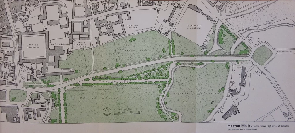
Debate over the planning proposals raged among the City Council, the University, and the Oxford Preservation Trust, and concentrated on the potential road across Christ Church Meadow. Many believed that a new relief road would only be accepted by locals if it was as quick to use as the route along the High, which ruled out any schemes that bypassed the meadow.[5]

Faced with irreconcilable clashes of opinion over the question of an inner relief road, the Council managed to resist a commitment to build one throughout the 1950s. This was despite the best efforts of Duncan Sandys, Minister of Housing and Local Government, who was determined that the only solution to the traffic problem was to build a road through the meadow. Although Sandys had allegedly received the support of the Cabinet – which included five “Christ Church men”, including Prime Minister Anthony Eden – the Oxford Mail commented that if a vote ever went to Parliament, the road would never receive the approval of the House of Lords. The Lords simply contained too many Christ Church alumni.[6]
In the 1960s, the plan was resurrected with a modern spin. The architect and town planner Geoffrey Jellicoe proposed to build a sunken road across the north part of the meadow, making the landscape appear undisturbed from a distance. The Council approved this plan in 1965, and a public inquiry into its effects was opened.
Naturally, the results were inconclusive. The Minister of Housing and Local Government at the time, Richard Crossman, was impatient for a swift solution to be found – with minimal public interference. When asked if there would be another public inquiry in 1966, he replied that he would have to use his discretion, ‘But my discretion will be prejudiced. I don’t see myself thinking another one will be required’.[7] By now, the city’s indecision over the road plans was a long-established national joke.
As debate continued, plans for various inner relief roads resurfaced and were newly quashed. One of these was the plan to build a road through a working-class area in east Oxford, Eastwyke Farm. In 1969, the Oxford Civic Society was formed to hold the Council to account for their failed attempts at town planning. Their first booklet outlined the dangers of the proposed Eastwyke Farm road. These included an increase in accidents, noise, and pollution, as well as the destruction of at least 174 houses.[8] This would not be the unopposed solution for which the Council had searched for so long.
The long-raging debates delayed roadworks in the centre long enough for the Park and Ride scheme, introduced in 1973, to ease the pressure off the city’s central roads. It was no longer possible to argue that an inner relief road was necessary. But if the City Council had not been paralysed by indecision for over forty years, Oxford would be a very different city – or perhaps, pair of cities – today.
Thomas Sharp’s plan for Oxford can be seen in the Weston Library’s Talking Maps exhibition until 8 March 2020.
Written by Elena Porter
References:
[1] G. Bardsley and S. Laing, Making Cars at Cowley: From Morris to Rover (Stroud, 1999), p. 34.
[2] Letter to the Editor, ‘The Morris Motor Works at Cowley’, The Spectator, 4 September 1926, p. 347.
[3] Mark Barrington-Ward, ‘Forty Years of Oxford Planning: what has it achieved, and what next?’, text of a lecture given in 2009. Available: https://www.oxfordfutures.org.uk/uploads/20100331_Forty_Years_Of_Oxford_Planning.pdf, p. 4.
[4] ‘This House welcomes Dr Sharp’s proposals for the replanning of Oxford’, 4 March 1948. Quoted in Dr Roland Newman, The Road and Christ Church Meadow (Oxford, 1988), p. 10.
[5] Barrington-Ward, Forty Years of Oxford Planning, p. 8.
[6] 29 September 1956. Quoted in Newman, p. 15.
[7] ‘Christ Church Meadow Road Winds On’, The Times, 27 Jan. 1966 (56540), p. 6.
[8] Liz Woolley, Changing Oxford: Fifty years of Oxford Civic Society 1969–2019 (Oxford Civic Society, 2019), p. 8.